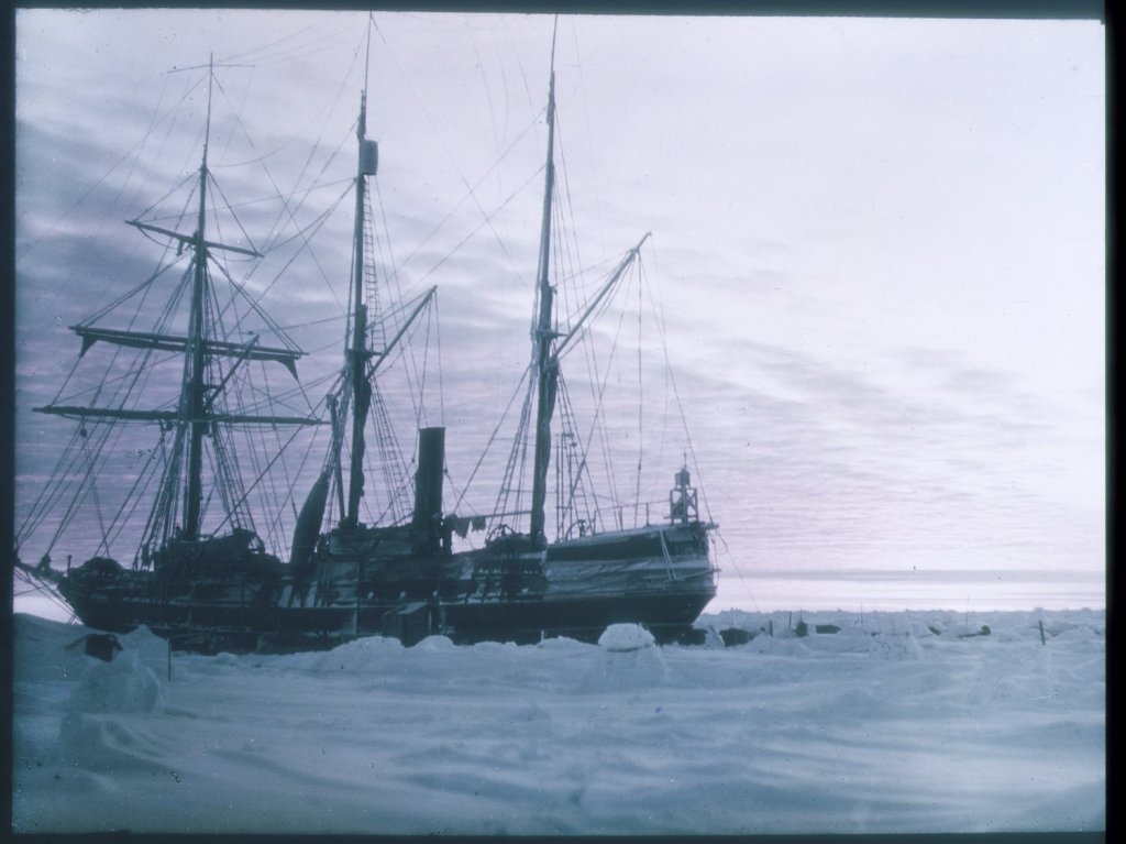
Endurance in Antarctic ice, 1915. Frank Hurley / State Library of New South Wales, via Wikimedia Commons. Digital reproduction: CC BY-SA 3.0 Australia. Compressed for web display; no crop. Image reuse under the linked licence. Image source. Rights and reuse.
The surviving name on Endurance’s stern made recognition immediate. Understanding the wreck is a slower task. A clear image can identify a ship and record an extraordinary amount of detail, but it cannot by itself establish the strength of the timber, the condition of hidden spaces or the rate at which the remains are changing.
Endurance was discovered on 5 March 2022, with the discovery announced four days later. The expedition recorded her at a depth of 3,008 metres in the Weddell Sea, upright and recognisable more than a century after sinking. Those are observations from the 2022 fieldwork, not evidence of a fresh survey in 2026.
The distinction matters because the wreck now exists for most people through photographs, models and reconstructed views. These can make an inaccessible site understandable without disturbing it. Their value depends on keeping the measured record, its interpretation and its presentation clearly connected.
| Item | Established record |
|---|---|
| Abandonment | 27 October 1915 |
| Sinking | 21 November 1915 |
| Discovery | 5 March 2022; announced 9 March |
| Recorded depth | 3,008 metres |
| Surface platform | S.A. Agulhas II |
| Survey vehicles | Two Saab Sabertooth hybrid underwater vehicles |
| Existing heritage designation | Historic Site and Monument 93, designated in 2019 |
Contents: Searching beneath the ice · Three ways to record a wreck · What survival establishes · Reassessing the sinking · From measurements to models · Protection and proposals · Preserving future evidence · Related reading · Sources
Searching beneath the ice required a surface system
The underwater vehicle attracts attention because it reached the wreck, but it was only one component of the operation. S.A. Agulhas II provided the working platform, launch and recovery capability, personnel and support needed to operate in the Weddell Sea. Sea ice affected access at the surface while the search took place far below.
The expedition’s marine archaeology account explains that conditions allowed the vehicles to launch directly from the vessel. Alternative ice-camp arrangements had been contemplated. A contingency plan is therefore not evidence that an ice-camp deployment actually occurred.
Two Saab Sabertooth vehicles carried survey equipment. Saab describes Sabertooth’s hybrid architecture as combining autonomous and remotely operated capabilities. Autonomy is useful for following planned survey patterns; remote operation allows people to inspect and respond to what the vehicle encounters.
Those capabilities should not be converted into an invented dive-by-dive narrative. A product description establishes what a system can do. Expedition records establish how it was used on a particular mission. The distinction is especially important when later versions of an underwater vehicle have different equipment or options.
The practical achievement was to bring a controlled observation platform to the right area, maintain knowledge of its position and recover its evidence. Finding the wreck and recording it demanded both underwater capability and a workable operation at the ice-covered surface.
Acoustic, optical and laser records answer different questions
Sonar helps search an area that cannot be inspected efficiently by a camera alone. Acoustic returns can reveal an object above the seabed and indicate its shape and relationship to surrounding terrain. This makes sonar useful for locating a candidate wreck before attempting close visual identification.
Photography supplies a different kind of evidence. It records visible fittings, surfaces and objects, allowing researchers to compare features with historical descriptions. At this depth, artificial lighting is essential. The camera sees the portion illuminated from its position, not the whole ship in natural daylight.
Laser scanning adds geometric information. Together with overlapping photographs, it can support a scaled representation of the remains. The Endurance22 archaeological account describes laser recording and photogrammetric coverage of the wreck and debris field. Survey-equipment supplier Voyis also documents its role in the project.
Photogrammetry works by matching visible features across overlapping images and estimating their spatial relationships. It gains value from consistent coverage and reliable scale. An object photographed from only one direction may look clear while still providing limited information about its full geometry.
These methods complement one another because each has blind spots. An acoustic shape may lack recognisable detail. A photograph may contain shadows, obscured surfaces or uncertain scale. A geometric model may be accurate where observations overlap and incomplete where the vehicle could not see.
For interpretation, the important question is not which instrument produced the most impressive image. It is whether the different records support the same conclusion, and whether the coverage is sufficient for the specific claim being made.
Recognisable does not mean structurally complete
The 2022 images established exceptional visual survival. The upright hull and identifiable details allow the wreck to be related to the ship that was abandoned in 1915. They also preserve spatial relationships between surviving components that would be lost if objects were removed individually.
However, the exterior surface is not the whole structure. Timber can retain its shape while its internal properties change. A visible deck or fitting does not certify that it could carry a load, withstand handling or survive recovery to the surface.
The non-intrusive survey deliberately avoided turning identification into physical testing. Consequently, visual evidence should not be stretched into measurements of residual timber strength. Nor does an apparently stable arrangement at one date establish a long-term trend.
The phrase well preserved needs an object: well preserved for recognition, for studying construction or for observing fittings. It should not silently become well preserved in every physical sense. Different research questions require different evidence.
The environment helps explain why so much remained visible, but environmental explanation is not a guarantee of permanence. Future observations could reveal changes in sediment cover, biological growth or the position of vulnerable components. Only comparable records taken at different times could show whether such changes had occurred and how large they were.
The wreck invites a more precise account of the loss
Endurance was abandoned on 27 October 1915 and sank on 21 November. Those dates describe different stages in the loss. The decision that the ship could no longer serve as a safe base came before the remains finally disappeared beneath the surface.
A 2025 study in Polar Record reassessed the often-repeated claim that Endurance was an exceptionally strong polar vessel. Its structural comparison examined framing, deck support and the machinery-space arrangement, rather than accepting reputation as a measure of resistance to compressive ice.
The study also challenged an explanation centred principally on rudder damage. It identified wider structural weaknesses relevant to ice compression. That is the authors’ reassessment, based on their analysis, and should be presented as such rather than as a new eyewitness account of the sinking.
This is where an archive can add value without pretending that every question has been settled. Historical testimony describes what people experienced. Construction evidence helps explain how loads could pass through the hull. The wreck records the resulting remains, but not an uninterrupted sequence of every failure.
Damage visible on the seabed may have more than one possible origin within the loss process. A responsible interpretation connects it with documentary and structural evidence before assigning a precise cause. The wreck is an important witness, but it does not supply its own complete chronology.
Digital reconstruction can extend access without extending the evidence
In June 2025, the Falklands Maritime Heritage Trust described a three-dimensional model and interactive display derived from the 2022 survey. Its account referred to more than 25,000 photographs and laser data, with a presentation for the Goodwood Festival of Speed.
The public benefit is substantial. A viewer can move around a coherent representation instead of trying to assemble the ship mentally from separate close-up frames. A physical model can communicate scale and arrangement to people who will never encounter an underwater survey interface.
But a model is a processed product. Images must be aligned, geometry assembled and visual information presented. Colour correction can make details easier to see; it does not show that daylight reaches the wreck or that the original camera captured the same balanced appearance in one exposure.
It is useful to distinguish a measured surface from a reconstruction of a missing component. Both may help explain a ship, but only the first is direct survey geometry. If a public presentation fills gaps for clarity, that treatment should remain distinguishable from the underlying record.
A credible research workflow would preserve the original imagery and survey information alongside the derived model. That allows later users to ask how a feature was represented and whether an interpretation can be checked. An attractive interactive display alone does not establish that a complete, openly accessible research archive exists.
Existing protection and a proposed ASPA are different things
Endurance received Historic Site and Monument designation 93 in 2019, before discovery. Measure 18 of 2024, effective on 28 October 2024, describes protection covering the wreck and associated artefacts within a radius of 1,500 metres.
That existing status must be distinguished from the proposed Antarctic Specially Protected Area. The 2026 ATCM 48 final report, paragraph 114 and Committee for Environmental Protection paragraphs 152 and 153, records agreement to forward the proposed management plan to CCAMLR for approval, with adoption envisaged at ATCM 49.
Approval of a plan at one stage of that process is not the same as completed designation. The 2026 record therefore supports an account of an advancing proposal, not a statement that the additional ASPA status was already in force.
The geographical extent of protection also matters archaeologically. A wreck site includes displaced objects and their relationships to the hull, not merely the recognisable vessel outline. Removing an isolated artefact can erase contextual evidence even if the main ship remains untouched.
Preservation should keep future questions answerable
The strongest case for non-intrusive documentation is that it preserves options. Observing an object in place leaves later researchers able to study its setting with improved methods. Removal changes that setting and introduces conservation obligations that do not end when an artefact reaches a laboratory.
Future monitoring would be most useful if it repeated defined observations rather than simply producing another set of striking pictures. Comparable viewpoints, scale, position and environmental records would make it easier to distinguish real change from differences in lighting or camera angle.
A trusted digital repository would strengthen that work by preserving original data, processing history and clearly dated versions. These are recommendations for good stewardship, not claims that a complete monitoring programme or open repository has already been delivered.
Endurance’s survival has made detailed study possible without raising the ship. The continuing task is to protect both forms of evidence: the physical remains in the Weddell Sea and the digital record through which almost everyone encounters them. Neither should be allowed to stand in for more than it can demonstrate.
Related reading
The Mary Rose archive article provides a contrasting case of recovery and conservation. It helps explain why recording a wreck in place and bringing a historic hull ashore create very different long-term responsibilities.
Sources
- Endurance22: discovery announcement and marine archaeology programme.
- Saab: Sabertooth; Voyis: Endurance survey project.
- Polar Record: Why did Endurance sink?, 2025.
- Falklands Maritime Heritage Trust: Endurance in 3D, 25 June 2025.
- Antarctic Treaty Secretariat: Measure 18 (2024).
- ATCM 48 final report, 2026, paragraph 114 and CEP paragraphs 152 and 153.


